Author(s): Alemayehu Biri*, Mangistu Jifara, Geshew Safara, Abraham Feyisa, Endale Bedada and Bikila Mangistu
The government has initiated wheat self-sufficiency strategies through increasing wheat productivity in the rain-fed agro-ecologies and expansion of production to the irrigable lowland areas. To this end, in 2019/20, the Oromia agricultural research institute and the Ethiopian institute of agricultural research have extended the experience to the high land and midland areas and not yet well introduced to the highland of north Shewa zone of Oromia. Therefore, the LSD was conducted in selected six districts (Jida, Abichu, Wacale, Degem, kuyu and Wara Jarso) of north Shewa Zone in 2020/2021 off season to popularize irrigated wheat production technologies practices and to encourage farmer-based seed production and supply systems under irrigation. Ogolcho and Kingbird varieties were used for large scale demonstration and planted on a total 162 hector of land. A total of 399 households and institutional producer who are members of organised Irrigation water users’ associations were involved in the activity. Before, class room trainings and stakeholder workshop were conducted to the participants from the selected districts on the overall activity implementation approach as well as bread wheat production and management under irrigation during off season. Accordingly, a total of 229 and 368 participants attended the training and field days, respectively. Yield data was collected and the result indicated that the maximum yield were recorded 58.7qt/ha and 48qt/ha at Abichu and Jida district, respectively. The outcome showed the presence of large and untouched productive areas suitable for wheat production under irrigation as to lead the areas to self-sufficient
Globally, wheat is the second important staple food crop next to rice and one of the most important strategic food and industrial crops. Ethiopia is one of the largest wheats producing countries in Africa [1]. It is the second most important food crop next to maize in Ethiopia. Currently, the crop covers about 1.8 million hectares of land with an estimated annual production of 5.7 million tons at an average productivity of 3.0 t/ha and number of HHs producing wheat: 4.2 million households [2]. Ethiopia has a huge potential and favourable agro-ecological condition for producing enough amount of wheat grain for domestic consumption and export. The production of wheat has been consistently increasing for the last 25 years, but much lower than the world average 3.3 t/ha [3].
Despite the production and area coverage, the country remains a net importer and imports about 1.7 million tons of wheat to meet its demand [2]. According to EIAR 2020 report, to alleviate this challenge the government has initiated a wheat self-sufficiency strategy through increasing wheat productivity in the rain-fed agroecologies and expansion of production to the irrigable lowland areas [3]. To this end, in 2019/20, the Oromia agricultural research institute and the Ethiopian institute of agricultural research have extended the experience to the high land and mid altitude areas. Therefore, as part of the above-mentioned work, Fiche agricultural research center has been one of the actors involved. However, the irrigated wheat production technologies are not yet well introduced to the remaining vast areas of the region. Thus, basing the experiences of 2019/20, a large-scale demonstration of irrigated wheat has been proposed to reach areas with no prior experience of producing wheat in north Shewa zone using irrigation with the following objectives.
To popularize irrigated wheat production technologies and
practices in north Shewa
To encourage farmer-based seed production and supply systems
under irrigation
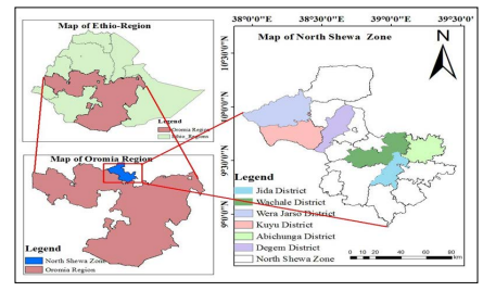
The large-scale demonstration of irrigated wheat activity was conducted in six districts of North Shewa zone, Oromia national regional state. North Shewa zone, with an area of 8990 km2 accounts for about 2.5% of the total area of Oromia. It is located between 9°05’ and 10°23’N latitude and 37°57’ and 39°28’E longitude. It is bordered by Amhara National Regional State, West Shewa zone, Finfine Surrounding Special zone and East Shewa zone. Fiche town is zonal capital, located at 112km from Addis Ababa, along Addis, Gojam main road. North Shewa classified into 13 rural districts and one town administrative town, 18 towns, 267 rural and 24 urban dwellers kebele’s. The zone is one of the potential zones with access to irrigation where by previous pilot irrigated wheat production activities were implemented. In the zone six districts were selected purposively based on their suitability for irrigatedwheat production, availability of the irrigation infrastructure and on the behalf of each district’s agricultural office. The selected districts were Jida, Abichu, Wacale, Degem, kuyu and wara Jarso.
Jida District is located at a distance of 71km from Addis Ababa to the north, along Addis Gojam main road. It is also found at a distance of 74km from Fiche town to the south. The district has a total area of 654km2 (65,400 hectares). The district is bordered by Bereh district to the south, Aleltu district to the south-east, Sululta district to the west, wacale district to the north-west, Abichu Gnea to the north-east and Kimbibit district to the east and has 13 Peasant Associations. Altitudinal elevation of the district ranges between 2600m-3500m. The major rivers of the district are Aleltu, Jage, Wasarbi, Kalate and Robi. Mainly, the rivers are used for irrigation, human being and livestock drinking and washing. The district is characterized by dega and woina-dega agro-climatic zones. Average annual temperature of the district is 14°c, while annual average rainfall ranges between 635 and 1350mm. Major rainy seasons of the district are summer and Belg. There are two major soil types in Jida district, namely clay and sandy soils. The major crops produced are barley, wheat, tef, triticale, oats, field pea and faba bean and mixed farming system is more practiced in the area [4].
Abichu-Gnea District is located 157 km from Addis Ababa, along Addis, Desie main road and 227km from Fiche town. It lies between 9°29’- 9° 50’N latitude and 39°02’- 39°20’E longitude. The district has an area of 544 km2, of which about 52.7, 32.2 13.6 and 1.0% are cultivable, grazing, settlement and vegetation covered area, respectively. Abichu Gnea district is bordered by Kembibit to the South, Jida to the south-west and Wacale to the west and Amhara National Regional to the east and north. The altitude ranges from 2,590 to 2,843m. The well known rivers in the district are Gabisa, Bilet, Aragesa, Dawe and Boru. Dega (92%) and Weina Dega (8%) are the two agro-climatic zones of the district. The average annual rainfall of the district ranges between 800 and 1100mm, while average annual temperature is about 15°C, with a minimum of 10°C and maximum of 25°C. The district has bi-modal rainy seasons, namely meher rainy season from June to September and short belg rainy season from January to April. The major crops grown are tef, wheat and barley from cereals, lentils, field peas and horse beans from pulses and linseed and fenugreek from oil seeds [4].
Wacale District is located at a distance of 78km from Addis Ababa and 35km from zonal capital city (Fiche). Astronomically, the district is located between 90 25” & 90 47” N and 380 38’ & 390 55” E. Wacale district is bordered by Sululta in the south, Debre libanos & Amhara National Regional State in the north, Abichu & Jidda in East and Yaya Gulale in the West. The total area of the district is estimated about 698km2 . The altitude ranges from 2880m &1600m. The major rivers of the district are Alaltu, Robi Gomoro, Wasarbi, Nara, Mogor and Lego, whereas, Bulbula, Lami, Fichawa and Robi are the known streams. The Agro-ecological zones of the district are referred to Beda (Dega) which ranges from 2300 to 3300masl & accounts for about 69.8% and Beda Dare (Woina-Dega) ranging from 1500 to 2300mas accounting for about 30.2% of the total area of district. The average annual rainfall and temperature of the district is about 1800mm and 12°C, respectively. There are three major types of soil that exist in the district; Pelic vertisol, vertic cambisol and rendiznas. The major crops are; wheat, tef, barley, horse beans, field peas, lentils, nug and linseeds. Wheat is the dominant as compared to others. These major crops are mainly produced in both seasons (meher and belg) [4].
Kuyu District is composed of 23 Peasant associations and 3 kebele’s as urban administrative units. Garba Guracha is the main town, located at 42km from the zonal capital Fiche and 156km from Addis Ababa. Kuyu district is bordered by Wera Jarso in the North and North West, Hidabu Abote in the North East, Degem in the East and South East, Ginde Beret District of West Shewa Zone in the West, Meta Robi and Ada’a Berga Districts of the same zone in the South. It has an astronomical location of 9°35`- 9°49’N latitude and 38°03’-38°31’E longitude. The total area of the District is about 982km2 , accounting for about 10.92 % of the zonal area. The well-known rivers in the district are Muger, Weserbi, Warke, Garba Guracha and kote. Sombo, Dalati and Deyi are the main streams, while Kataba, Hole, Badesa and Welanso are the known springs in the District. The agro-climatic zones of Kuyu District by their altitudinal ranges are “Bada” (temperate) which is greater than 2,300 meters above sea level and accounting for about 50%, “Bada-Dare” (sub- tropical) which ranges from 1,500-2,300 meters above sea level and sharing 40% and “Gamoji” (Tropical) which is less than 1,500 meters above sea level and accounting for 10% of the District total area. The average annual rainfall ranges from 1,600-1,800 mm, while the average annual temperatures vary between 15°c and 18°c. The major soils are vertisols (55%), red or brown soil (20%) and ‘bole’ soils (20%) and others soil type’s cove 5% of district. The major crops grown in the district are tef, sorghum & wheat from cereals, horse beans & field peas from pulses and neug & linseed from oil crops [4].
Degem District is located at a distance of 125km from Addis Ababa, along Addis-Gojam main road. Astronomically, the district lies between 9°34’ to 10°N latitude and 38°39’ to 38°44’ E longitude. It is bordered by Hidabu Abote to the west and the northwest, Kuyu to the southwest, Girar Jarso to the east, Yaya Gulale to southeast, West Shewa zone to the south and Amhara National Regional State to the north. Hambiso town is district’s capital town. Degem district, comprising 18 rural kebele’s and two urban kebele’s, has an area of 686 km2 . The elevation of the district ranges from 1500 to 3541 masl. The main rivers of the district include Indris Guda , Lega Silmi, Weserbi, Kechema Tina, Leman Guda and Leman Tina. Badda (Dega), Badda Dare (Weyina Dega) and Gamoji (kola) covered about 30%, 32% and 38% of the total district’s area, respectively. The three major soil types of the district are vertisols or black soils, red soil and lime soil. The major crops grown in the district are barley, tef and wheat from cereals, horse beans and field peas from pulses and niger seed and flux from oil crops and potato and tomato from horticulture crops [4].
Wera Jarso District is composed of 29 kebele’s, where the rural parts have 25 farmers associations and the urban parts have 4 kebele’s in three towns. The main town of district is Gohatsion, located at 73km from the zonal capital of Fiche and 185km Addis Ababa. The District is bordered in south by Kuyu, Hidabu Abote in the East, Dera in the North East, Gindeberet of West Shewa Zone in the South- East and Abay River in the North and North-West. The astronomical location of the District is approximately 9°47 10°11 N and 38°27-38°43 E latitude and longitude respectively. The total area of Wera Jarso district is 1207km2 , which is the second largest District of the North Shewa zone. The major rivers of the District are Abay, Jema, Muger and Milki, while Kersa, Belo, Gufte and Gede are known streams. The agro-climatic zones of the District by their altitudinal ranges are Beda (temperate), located between 2500-3500m accounts for about 15%, Beda Dare (sub-Tropical), located between 1500-2500m accounts for 30% and Gamoji (Tropical) that ranges from 500-1500m shares 55% of district’s area. Mean annual temperature of the District ranges from 21 to 30°C, while mean annual rainfall ranges from 800mm to 1400mm. Dominant soil types of the district are Red soil, Vertisols, and Bole soil. It is suitable for growing crops such as Tef, Wheat, Barley, Sorghum, Peas, and Beans [4].
The approach used was large scale demonstration using cluster farming. The varieties were planted on a total of 162ha. The participant farmers who allocated the land are neighbouring farmers who own land in either irrigation scheme or are member of Irrigation water user associations. These farmers are then organised using cluster approach.
Before commencing on the actual implementation stakeholder analysis and sensitization was conducted. Accordingly, four important stakeholders were identified Research center, office of agriculture at district level, Salale farmers’ cooperative unions (FCUs) and farmers. The sensitization took place during the initial training session. All the four stakeholders agreed upon set of roles and responsibilities serving for efficient allocation of resources and successful implementation of the activity.
The potential irrigation areas were selected based on accessibility to visit and monitoring. The LSD was conducted in selected six districts of north Shoa Zone. In each district one Kebele was selected except at Jida district three kebele’s were selected in collaboration with experts who are members of technical team organised for irrigated wheat related activities from district office of agriculture. The kebele’s were selected purposively based on their irrigation access and suitability for irrigated wheat production. In each district participant farmers whose farms adjacent to each other were selected to form clusters. Thus, at least in each district 3 to 75 hectares of land were selected based on their access to irrigation water, availability of irrigation infrastructure and previous history of their land for basic seed multiplication. For the implementation a total of 9 kebele’s, 9 clusters and 162 hectares of land were used. The table below showed that the formation of clusters and areas of production in each district.
| Zone | Districts | Kebele | Clusters | Area (ha) |
|---|---|---|---|---|
| North | Jida | Da bali, Wanya Qore & Ganda Dhaka | Jida | 75 |
| Shewa | Abichu | Adare Ejersa | Gabisa | 10 |
| Ogle & Dayole | 25.5 | |||
| UjubaQal’aa | 8.5 | |||
| UjubaGuda | 14 | |||
| Wacale | Liqime | Liqime | 12.5 | |
| Dagam | Ali Doro and Elele | Elele | 4.5 | |
| Ali Doro | 4 | |||
| Wara Jarso | Bobe Liban | Bobe Liban | 3 | |
| Kuyu | Amuma | Amuma | 5 | |
| Total | 6 | 9 | 9 | 162 |
Both theoretical and practical training was given to farmers, subject matter specialists (SMS), development agents (DAs) before planting and after planting. Farmers was trained two to three times in the production season preferably at the beginning (before starting the activity and during cultivation) and at vegetative stage of the crop (weeding, irrigation and pest management). The farmers were given class room training and practical orientation prior to planting. The training covered issues from input preparation until harvesting and post-harvest handling of the bread wheat production using irrigation. Field days were organized at crop maturity stage at district and zone levels. Moreover, radio and TV broadcast were made to share the experiences to the wider public through OBN Oromia Broadcasting Network. Documentation of the entire process; i.e. training events, land preparation, planting, field management, harvesting and threshing, field visits, field days, stakeholders’ participation and yield results in written form, pictures and videos was made.
Certified seed was accessed through Biftu Salale farmers’ cooperative union whereas as basic seed was received from Oromia seed enterprise (OSE). Fertilizer, herbicide, insecticide and fungicide were purchased and provided to farmers fully by Fiche Agricultural Research Center. About 225 quintals of basic seed of ‘Ogolcho’ variety and 18 quintals of certified seed of ‘kingbird’ wheat variety was distributed to farmers. Additionally, about 158 quintals of NPS, 243 quintals of urea, 35L of Pallas, 135L of karate and 105L of Nativo were provided for the farmers.
Ogolcho and Kingbird bread wheat varieties used as planting material. Both basic seed and certified seed (C1) classes were used. The varieties were selected based on previous experiences in irrigated wheat production and its suitability to the agro-ecology of the study area. Land was prepared in the form of groups and cooperatives by oxen plough in most but except Gabisa cluster was ploughed by tractor. All the oxen ploughed 2-3 times except at Gabisa cluster, first and second were ploughed by tractor. Planting was done through broadcasting. Seed bed, seed covering and furrow making were done by using oxen. All farm operations landpreparation, planting, weeding, agro-chemical spray, harvesting, threshing was carried out by the participating farmers with close supervision of researchers and district level agricultural experts.
A seed rate of 150kg/ha, fertilizer rate of 150kg UREA and 100kg NPS were used. UREA was applied using split application where 1/3 was applied during planting and 2/3 at tillering stage. Recommended packaged production and management technologies and practices (seed rate, spacing, fertilizer management and weed management) for bread wheat production were used. Irrigation watering frequencies varies from district to district based on the soil type and water potential but irrigation frequency of 10-15days. The irrigation frequency is higher at early stage for uniform land coverage and maintained uniform after tillering.
| Districts | Variety | Class | Seed (qt) | Fertilizers (qt) | |
|---|---|---|---|---|---|
| NPS | Urea | ||||
| Jidda | Ogolcho | Basic | 122.5 | 66 | 122.5 |
| Wacale | Ogolcho | Basic | 15.7 | 13 | 15.7 |
| Abichu | Ogolcho | Basic | 80 | 61.5 | 80 |
| Dagam | Ogolcho | Basic | 6.8 | 5.5 | 6.8 |
| Kingbird | Certified | 6 | 4 | 6 | |
| Wara jarso | Kingbird | Certified | 4.5 | 3 | 4.5 |
| Kuyu | Kingbird | Certified | 7.5 | 5 | 7.5 |
| Total | 243 | 158 | 243 | ||
| Districts | Herbicide | Insecticide | Fungicide | |||
|---|---|---|---|---|---|---|
| Name | Amount(L) | Name | Amount(L) | Name | Amount(L) | |
| Jidda | Pallas | 22 | Karate | 70 | Nativo | 56 |
| Wacale | Pallas | 3 | Karate | 10 | Nativo | 9 |
| Abichu | Pallas | 10 | Karate | 50 | Nativo | 40 |
| Dagam | - | - | Karate | 5 | - | - |
| Total | 38 | 135 | 105 | |||
Amount of inputs distributed, grain yield, total number of farmers by gender participated in the activity, trainings, field days and visits, and feedbacks were collected. The data were collected using checklists and data collection sheets.
Descriptive statistics mainly was used to analyze the grain yield. Other quantitative gender disaggregated data were described using tables. Farmer feed backs were summarized qualitatively and described using tabular presentations.
| Involved Stakeholders | Roles |
|---|---|
| OSE |
Provide required amount of seed Seed quality assurance and certification Sign contract agreement with farmers and monitoring of the fields |
| Salale university | Provision of logistics |
| BoA at each district level |
Select and organize farmers into clusters Assist in site monitoring and evaluation of activities in each cluster Support in providing training, field days and visits Assist during input distributions Providing water pump |
| SFCUs |
Supply of agricultural inputs (Fertilizers, herbicide, insecticide, fungicide and spray pump) Provision of seed |
The selection of participant farmers and cluster formation was conducted in collaboration with experts from each district office of agriculture.
| Zone | Districts | No of Kebele’s | Land size (Ha) | No. of farmers involved (HH’s) | ||
|---|---|---|---|---|---|---|
| Male HH's | Female HH's | Total HH's | ||||
| North | Jida | 3 | 75 | 187 | 31 | 218 |
| Abichu | 1 | 58 | 132 | 5 | 137 | |
| Wacale | 1 | 12.5 | 20 | 5 | 25 | |
| Dagam | 2 | 8.5 | 27 | - | 27 | |
| Wara Jarso | 1 | 3 | 4 | - | 4 | |
| Kuyu | 1 | 5 | 8 | - | 8 | |
| Total | 9 | 162 | 358 | 41 | 399 | |
After cluster formation, selected farmers from each district who are members of organized cluster took one day training including practical sessions. About 229 participants got awareness on the need and importance and technical aspects of irrigated wheat production in north shewa zone. Both theoretical and practical training was given to farmers, subject matter specialists (SMS), development agents (DAs) and platform members on crop management, and seed production packages. Training plan was prepared with clear objectives, outputs, method of training, trainers and schedule. Farmers training were mainly carried out more of on farmers’ field unless there is a special necessity to conduct it in the research center. The following table describes training participants in gender disaggregated manner.
| Training topic | Total no of Participants | Number of participants | |||||||
|---|---|---|---|---|---|---|---|---|---|
| Farmers | Das | SMS | Total | ||||||
| Crop management and seed production packages. | 229 | M | F | M | F | M | F | M | F |
| 187 | 31 | 2 | 1 | 6 | 2 | 197 | 32 | ||
Mini field days were organized in collaboration with district agricultural development offices and farmers at Abichu, Wacale, Dagam and Wara Jarso. It was arranged to create awareness and farmers shared experience and knowledge on irrigated wheat technology. Regular joint monitoring and evaluation (follow up actions) and provision of technical advice were undertaken at different crop stages based on necessary emerging knowledge/skill and technical advice needs. Field day was a method of motivating people to adopt new practices by showing what has already achieved under field conditions. In other words, it was to show the performance and profitability of new practices/technologies/innovation and to convince about the applicability. Besides, it was a way of facilitating people to visit new innovation for the purpose of bringing mass mobilization. Thus, mini field days were organized at each demonstration site in order to involve key stakeholders and enhance better linkage among relevant actors. Discussion session and result communication forum were also organized. Thus, a total of 368 participants among 87 females were attended field days in the course of implementing the activity.
| Training topic | Total no of Participants | Number of participants | Number of participants | Number of participants | ||||||||||||
|---|---|---|---|---|---|---|---|---|---|---|---|---|---|---|---|---|
| Farmers | Experts | Others | ||||||||||||||
| Irrigated bread wheat | 368 | M | F | Total | M | F | Total | M | F | Total | ||||||
| 249 | 81 | 330 | 29 | 6 | 35 | 3 | - | 3 | ||||||||
At Abichu and Wacale the yield was performed well but poor performed at Dagam due to water shortage and lack of water pump. At Jida about 70ha of land affected by frost (cold temperature) at heading and recommended for grain, only about 5ha of land was performed well and evaluated by committee for seed certification. The collected yield data from each district were presented and described by (Table 9). Accordingly, higher yield of Ogolcho variety was recorded at Abichu district followed by Wacale district. The increment in yield could be associated with the better management and water utilization difference among farmers. The major achievement of yield performance was described below table.
| District | No Kebele’s | Area (ha) | Yield(qt) | Mean yield (qt/ha) | |
|---|---|---|---|---|---|
| Min. | Max. | ||||
| Jida | 3 | 75 | 20 | 48 | 34 |
| Abichu | 1 | 58 | 30 | 58.7 | 44.35 |
| Wacale | 1 | 12.5 | 30 | 40 | 35 |
| Dagam | 2 | 4.5 | 20 | 30 | 25 |
| Wara Jarso | 1 | 3 | 20 | 30 | 25 |
| Kuyu | 1 | 5 | 25 | 32 | 28.5 |
| Grand mean | 26 | 24 | 40 | 32 | |
Target farmers were happy and well perceived the importance of wheat production technologies under irrigation. Fear of Birds, pests and water shortage (needs high amount of water) because farmers not produce wheat during dry season but vegetables are common to produce under irrigation in the study areas. Therefore, they have decided to grow the wheat varieties under irrigation and share the available seed to other follower farmers who eagerly follow the irrigated wheat production.
| Challenges Encountered | Measures Taken |
|---|---|
| Cold chilling and frost | Immediate irrigation of the field/watering |
| Shortage of water | Irrigation scheduling (calendar) |
| Yellow rust disease | Using chemicals to control |
| wheat Aphid | Using chemicals and frequent irrigation to control |
| Bird attack | Guarding and using traditional methods (furrisaa, fishkaa, qaccee, making loud sound) |
| Resistance of farmers and dependency syndrome | Convincing, creating awareness |
| Pump failures (suction and discharge potential of pumps was not as expected), Lack of spare parts, late supply) | Maintenance up to possible level, using additional pumps |
| Shortage of pump Hose | Using additional pump hose by buying from the market |
Irrigated wheat production need attention and strong extension system are ensuring the sustainability of wheat production in the highland areas of the country. The demand is high wherever there is enough water to produce wheat production under irrigation. Adjusting time of planting and frequent irrigation is very important for wheat production to control frost/chilling injury. Linkage and knowledge sharing between stakeholders, farmers and researchers is successfully to produce wheat production under irrigation. The outcome shows presence of large and untouched productive area suitable for wheat production under irrigation as to lead the areas self-sufficient. The importance of team work among different institutions to accomplish successful farmers-based seed production, technology demonstration and scaling up. Listing and careful understanding perception and indigenous knowledge of farmers, so as to teach them about the new technology is very crucial.
Importance of practical on farm training to improve the skill farmers on irrigated wheat production. Watering needs a serious and frequent follow up and monitoring as farmers may not provide based on the schedule even in the presence of sufficient water. The production of irrigated wheat can provide good opportunity to multiply high quality seed during non-rainy season. Farmers or Farmers’ Cooperatives can be licensed to produce seed so that they can be more profitable by producing irrigated wheat and also increase seed availability for the entire wheat production system. Cold temperature is the major problem of north shewa zones so it needs high research investigations based on agro ecology of the areas. To this end, awareness creation to changing farmers and others stakeholder’s perception will be more important and effective for further adoption and intensification of irrigated wheat production.
Based on the findings and the experiences gained in the course of irrigated bread wheat production in North Shoa zone the following recommendations are given:
The authors are grateful to Oromia Agricultural Research Institute for allocating required budget and technical support. OARI is also acknowledged for allocating vehicle for the purpose of this activity at critical time when Fitche Agriculture Research Center (FiARC) was challenged with lack of vehicle. All the stakeholders involved and irrigated wheat technical committee in LSD of bread under irrigation were also acknowledged. We would also like to acknowledge FiARC staffs for their different facilitations.